Showing posts with label humanity. Show all posts

Monday, February 24, 2020

Why Colchis?


"The wealth of the regions about Colchis, which is derived from the mines of gold, silver, iron and copper, suggests a reasonable motive for the expedition of Jason."

Strabo, Geographica, 1.2.39


Excavation at Vani, Georgia - Colchian city.  (Author's Collection. Copyright 2020)

    In today’s “age of reason”, we use science to explain our world.  In the previous world it was religion that explained how things worked and before that, it was myth that gave reason to our world.  

Strangely, even today, the Caucasus is a world of myth.

    Myths and legends carry a powerful message through time - how the tellers of these tales view themselves.  Every tribe under the sun has these stories - each rooted in a time too distant to remember and each of them fascinating.  Yet all of these legends have one thing in common - they stand the test of time.  We, as people, are inextricably bound to the past: it makes us what we are today and shapes what we will become tomorrow.  One could even say that without the past there would be no future.


Waterfront in Batumi, Georgia - eastern Black Sea (Author's Collection. Copyright 2020)

    Strabo describes the wealth of an ancient civilisation as the plausible impetus for one of history’s most enduring myths but perhaps the wealth described by Strabo above can be explained by an even older Georgian myth.

In the beginning, God created the Earth and all its people.  He then asked all the people to attend a gathering so that he may parcel out all the lands of the Earth to them for habitation.  On the appointed day, all the peoples of Earth gathered and received, from God, what we call today their ancestral homelands.  Conspicuously, one group of people was not present, but God went ahead and gave the lands out as gifts to those that were.  Once all the lands were dispersed and the people departed from the gathering, the one missing group arrived.  God said unto them, “My children, I’m sorry but you are late and no land is left to be given unto you as a home.  Where have you been?”  The group replied to God that they had been feasting and toasting God’s good name and his benevolence and, according to their traditions, could not stop the feast in order to attend his meeting.  They apologised profusely but re-iterated that they were late because their particular form of worship had deterred them from arriving on time.  So the Lord spoke to this group of people and said, “You are a genuine and pious people who deserve a good homeland, as such, I will give unto you the place on Earth I had reserved for myself: Georgia.


10th century AD (approx) ruins overlooking Rioni River 
from Bagrati Cathedral in Kutaisi, Georgia
(Author's collection. Copyright 2020)

    God’s reservation of Georgia as his own refuge could be an acceptable reason for us to believe in the incredible mineral wealth of the region and through time, this could have manifested itself in the great wealth of the empire of Colchis.  This empire on the eastern end of the Black Sea in today’s Georgia was the target of Jason and his boatload of adventuring heroes.

Colchian anthropomorphic figures in main sqaure fountain. Kutasisi, Georgia
(Author's collection. Copyright 2020)


Monday, January 27, 2020

Time and Patience: the Most Powerful Warriors. Part Six

    Our quest for calendrical stations continues on the western end of Chaco Canyon.  Peñasco Blanco was rumoured to have a calendrical station marked by standing stones (according to Cosmo Mindellef in 1891) but the area can’t be found today.  Even further west, approximately five kilometres, is another great house: Casa del Rio.  This relatively small house (21-27 rooms), strangely, has produced the largest refuse pile of any other Chaco Canyon house.  It is along the Great West Road and has signs across the site of increased pedestrian traffic which may indicate avenues of ritual procession.  Additionally, the amount of refuse being dumped here decreased in/around 1100AD - just when a resurgence of building in Chaco Canyon proper began.  This all may suggest that Casa del Rio was a very important early festival site.  Visually, from Casa del Rio the Winter Solstice sun would have risen over a shrine on West Mesa named 29SJ 1088 - which sits on the highest feature on the southeastern horizon from Casa del Rio.  Additionally, use of selenite reflectors or fires would allow for instantaneous notification over the eight plus kilometres distance into downtown Chaco(Signal Towers, another topic for another entry).  
    The last category has to do with the larger application of Chaco Canyon itself as an observatory.  Recent data concerning this was uncovered by Anna Sofaer, Robert Weiner and William Stone and published in 2016 in The Science of Time 2016, entitled, Inter-Site Alignments of Prehistoric Shrines in Chaco Canyon to the Major Lunar Standstill.  

Satellite imagery showing location/inter-relationship of Chacoan shrines relative to the major Lunar standstill (taken from Inter-Site Alignments of Prehistoric Shrines in Chaco Canyon to the Major Lunar Standstill, 2016)
This paper outlines the discovery of numerous masonry shrines spanning the distance of five to 15 kilometres which are aligned to the major lunar standstill.  This hypothesis is re-enforced by Geographic Information System (GIS) analysis of the spatial distribution of these sites and includes precise geodetic coordinates determined by the National Oceanic and Atmospheric Administration’s Geodetic Survey.  This data clearly shows these shrines and their inter-relationships along azimuths to the rising and setting moon at its major standstill. 

Azimuths between Chacoan shrines in previous image ((taken from Inter-Site Alignments of Prehistoric Shrines in Chaco Canyon to the Major Lunar Standstill, 2016)


    Overall, the evidence for calendrical stations in Chaco Canyon is overwhelming.  It is for us to try to decipher what they mean and what their role was in Chacoan culture.  It would seem that Chacoans did their best to improve calendrical precision by increasing vigilance in broader patterns across the ground while improving the speed of reporting to the central authorities.  With this in mind, we should ascertain that calendrical reporting was of paramount importance in the canyon.  Whether this was simply for projecting best corn and bean planting dates or used as a force multiplier in their quest for regional economic dominance may never be known.

Monday, January 20, 2020

Time and Patience: The Most Powerful Warriors. Part Five


    The calendrical station is our last subject concerning archaeoastronomy in Chaco Canyon.  This most recent subject is one of great controversy due to the willingness (seemingly) of some investigators to use irrelevant information in a relevant manner in order to aggrandise the Chacoan culture (alla Keynesian economics).  There is no need for that as Chacoan astronomy and its resultant culture are mind-boggling.  We will stick to facts alone in this article.
    Chacoans watched the sky, day and night.  Ethnographic proof is evident in every Pueblo tribe extant today and some are more ardent watchers than others but every tribe has astronomers.  This overwhelming commonality speaks volumes about the importance of the sky to Ancestral Puebloans.  

Super nova pictograph below Penasco Blanco.  Thought to be from an event in 1054 when an imploding star was visible during the day.
(Author's collection. copyright 2019)

Calendrical stations, simply put, are specific locations from which to track celestial activity across the sky.  Besides being a nice, relaxing pastime, this activity is the key to successfully charting solar activity as it relates to the time of year and - in a larger sense - when to conduct certain activities, like the planting of crops.  Properly conducted, this activity also allowed the Chacoan hierarchy to prepare the masses for upcoming festivals.  This would allow pilgrims travelling from satellite regions to be on time as well as markets to be prepared for the pending events: markets which strengthened the economy of the Chacoan World and re-inforced the validity of its ruling class.
    In Chaco Canyon there are several examples of calendrical stations and they are all linked to the fluorescence period.  In large part, these sites are associated with winter solstice prediction and are located near the Wijiji and Kin Kletso Great Houses as well Headquaters Site A (a backfilled site near Una Vida Great House).
   The original construction of Kin Kletso was completed by 1130AD (approx) and contains both anticipatory and confirmatory markers of the Winter Solstice.  Aligning the southern wall of Kin Kletso with the base of the cliff to the southeast gives a 16 - 17 day anticipation of the solar event and sighting the northern wall against the same cliff base indicates the day of the solstice itself.  Additionally, a large boulder near the north wall may have been the original calendrical station prior to construction.
    
Kin Kletso looking SW from canyon rim.  Previous calendrical station is the large rock (on canyon floor) in upper right picture in line with structure's north wall (Author's collection.  Copyright 2019)
    In the eastern end of Chaco Canyon is another great house: Wijiji.  This location was apparently built in one effort in 1110AD (approx) and was never occupied, lending credence to the supposition that it was created specifically as a calendrical station and fuelling speculation that this was an effort to revitalise a faltering religio-economy.  This great house exhibits signs of both anticipatory and confirmatory  stations in its architecture as well as in the surrounding terrain.  When standing at the northwest corner of the structure looking southeast, there is an apparent notch on the distant horizon.  16-17 days prior to the Winter Solstice sees the sun rising from just North (left) of this notch and the sun rises just to the South (right) of this notch on the solstice itself.  It is the preponderance of these visual astronomy references in Late-Bonito Phases great houses that is most interesting.  This site at Wijiji is impressive due to the number of calendrical stations in its vicinity.  To the East of Wijiji, there are boulders at three different locations that, coupled with a horizon foresight, act as calendrical stations for Winter Solstice, both equinoxes and Summer Solstice.  There is evidence that these sites were used subsequently by Pueblo tribes as well.


Monday, January 13, 2020

Time and Patience: the Most Powerful Warriors. Part Four

Another manifestation of Archaeoastronomy extant in Chaco Canyon is Cardinal       alignments.  North-South and East-West building orientations predominated during the flouresence period in the canyon (1000-1175 AD circa) and were so important by that stage that, in the case of Pueblo Bonito, an existing great house was expanded upon and re-oriented from the original S/SE floorpan to North-South alignment.

(Imagery courtesy of Google Earth)


    As opposed to the ancestral veneration as the basis for the S/SE orientation, I have found no clear ethnographic reasons for the cardinal alignment.  In fact, our concept of the cardinal directions would not have existed for the Chacoans; their understanding of the world was not like ours.  Perhaps the emerging reliance upon North-South alignments during the fluorescence stemmed from Chacoan understanding of the rotation of the cosmos through direct observation.  Long term observation of their revolving skies may have brought them to the conclusion that the cosmos rotates from a single point on either end of their world (North-South).  Their daily observation of the sun’s patterns - either through direct monitoring, horizon calendars or employment of a gnomonic device (see part two) - would have given them a good understanding of what we call East-West and, together, these concepts could have been employed to revitalise a flagging theocratic civilisation based upon this new cosmic concept.  
    These rumination aside, we are left with only the facts. The reasons for these orientations are not clear, there appears to be no utilitarian reason for the cardinal alignment (much less its sudden importance) and there are no topographical restrictions that would require construction to adhere so closely to these alignments.  The collection of solar heating may have been a factor in general south facing construction but there is nothing extant to insinuate such strict adherence to a cardinal azimuth.  Recent archaeological activity in Chaco Canyon suggests that even at the height of its fluorescence, Chaco Canyon had a rather small population that population surged at intermittent periods.  This suggests a religious employment of the site and would explain why the area was so well organised and such care was taken in its large-scale construction.  In this scenario (religious centre) the attention to detail would make sense if these great houses were built as physical manifestations of Ancestral Puebloan’s cosmic concept.  If this idea were true, even the act of building the great houses would have become an act of faith or contrition.  An idea like that may be reason enough for individuals without knowledge of the wheel and no beasts of burden construct an intricate road system over which to transport tens of thousands of trees from distances of up to 80km for use in construction of these houses.
    The question is what happened to cause a change in construction management? During this fluorescence period - when a surge in great house construction took place - almost every building exhibits signs of cardinal point orientation and there are several cases of inter-site alignment along the cardinal points as well, which indicates an even greater level of civil engineering on behalf of the Chacoans.  The construction of several buildings within Chaco between 1040 and 1160 AD (finish dates) demonstrate a clear premeditation on behalf of the Chacoan leadership to inter-relate their construction developments with regards to their cosmic concept.  Pueblo Alto, New Alto, Tsin Kletsin and Casa Rinconada are all flourecence era construction that are not only built with respect to the N-S alignment but are also aligned to each other despite their positions being separated by almost five kilometres.   Pueblo Alto, finished in ~1040AD, with an internal alignment of 178.9º is directly North of Tsin Kletsin.  Tsin Kletsin, finished in ~1115AD and due South of Pueblo Alto - constructed with an internal alignment of 178.7º.  Interestingly, these two great houses are outside of the canyon proper, on the mesas North and South of the canyon and in sight of each other; leading to conspiracy theories concerning warning stations and internal strife.  New Alto is a smaller great house within sight of, and directly to the West of Pueblo Alto.  This New Alto great house was constructed in approximately 1130AD and is directly North (and also within sight of) Casa Rinconada.  Casa Rinconada is located in Chaco Canyon (away from other great houses) and was constructed in ~1060AD and has an internal alignment of 180.1º.


    Through all of this the enigma remains (or deepens) because as cardinal alignment began to supersede S/SE orientation as the predominant expression of archaeoastronomy in Chaco Canyon, we see that same S/SE orientation become predominant in the Totah Region of the Chacoan world.  This region was at the northern end of the Great North Road and the destination for many during the initial abandonment of Chaco Canyon.  This simultaneous shift seems to indicate a rift in cosmic concepts.  Perhaps those that believed in the old ways moved North and built Aztec and Salmon Great houses along with their associated outliers while the “new” philosophy of cardinal alignment took over in the Chaco core.  

Monday, December 2, 2019

Time and Patience, the Most Powerful Warriors. Part Two


    While writing notes on southeast orientation and Cardinal points, I realised that I must address some basic facts and ideas as a precursor to understanding the Chacoan astronomy/architecture nexus.  
    Time in our world is created by two activities; the spinning of the Earth and the Earth’s rotation around the Sun.  Due to the former we have sunrise and sunset (the time of day) and from the latter we enjoy the change of seasons (the time of year).  Through these two types of time, the sun weaves its way across our skies in specific, observable patterns and it was these patterns and conditions which were closely observed by the ancestral Puebloans and became intrinsic to their very existence.
    Through the migration vignette from part one we see that these ancients understood the concept of direction, even if they didn’t have a word for azimuth, declination or Altitude.  As proof today, we have their repeated use of specific directions in their architecture over centuries of building.  This could have been easily accomplished through the use of a gnomon.  The gnomon is a simple tool for determining direction/time through observation of the sun’s movement and was first developed in Babylon though examples exist in the ancient world from China to Peru.


    A gnomon is built by placing a straight stick vertically in level ground and marking the location of the stick’s shadow on the ground through the course of the day.  This will quickly reveal the Cardinal directions and the device is eerily similar to the star tracking “compass” stick described in our migration myth from part one.  With a little ingenuity, this device can be a mobile compass as well.  To employ it one has to first determine the desired direction of travel.  Runners are then sent towards that direction and in the opposite.  These runners merely determine a straight line path through the gnomon itself and begin movement in the desired direction - always traveling in three parties and always re-evaluating their direction using the previous two points and terrain references prior to advancing.  If the party becomes lost or unsure, they merely stop for a day, set up the gnomon, verify the directions and begin again.
North wall of Aztec West great house which is aligned with summer solstice sunrise
(Author's collection. copyright 2019)
    Through close observation over time, a gnomon can also determine the azimuth of the equinoxes and the solstices.  When this began to happen, our ancestral Puebloans were determining annual calendars through the sun’s predictable nature.  Every March and September 21, the Sun rises and sets on the East-West meridian and its declination (distance from the Equator to the Poles measured in degrees) is 0 out of a possible 90 degrees.  Additionally, the gnomon can track the sun’s behaviour through its Winter and Summer Solstice declinations which are a positive or negative 23.5 degrees depending on the time of year.   The gnomon can also determine the altitude of the sun, track the Moon's activity through the full moon cycle and is a carpenter's square.  When this level of expertise is reached, the gnomon is a formidable weapon for nation building.  Horizon calendars can be created and future plans can be made on a grand scale.  Those grand scale plans can be employed to serve specific purposes which can, ultimately, manipulate public opinion and ideals.  

    When utilised in this fashion, our gnomon ceases to be a simple stick in the ground and becomes a sceptre of national power.  In this simple devise lies the power to legitimise rulers by “commanding the heavens” and thus, compel subjects to build organised cosmic cities which create an infrastructure based on that cyclic nature.   Their hard work is rewarded by security, well-planned festivals and markets centred around these cosmic events which stabilise lifestyles, build a vibrant economy and, ultimately, come to define them as a culture.

Specific events tied to an horizon calendar providing anticipatory warning for festival preparation.   (Author's composition)


Monday, November 11, 2019

War by Other Means, Part Three


    At the northern end of the Chihuahuan Corridor, Chacoans were developing their great house culture and they had also begun inter-pueblo integration between their outlying communities.  By 1150, the increased complexity of society on both ends of the Chihuahua Corridor created new markets and new production centres.  

Tri-walled Kiva at Pueblo del Arroyo, Chaco Canyon, New Mexico. (Author's collection copyright 2019)

    Of course, the increased trade could have had a synergistic effect on social development - especially within the elite classes.  Because of this situation, Casas Grandes, previously an outpost along the Chihuahua Corridor, grew in size and came into direct competition with the Hohokam society’s shell trade.  This shorter and more direct trade route, coupled with new Mesoamerican metallurgical techniques in copper and advances in aviculture practices seem to have sounded the death knell for Hohokam hegemony.  The Chalchihuites provided luxury goods in quantities and at delivery speeds that the Hohokam could not match.  By this time evidence shows Hohokam culture had retreated from its advance posts like Winona and Stony Canyon to their strongholds of Papaguería, the Gila-Salt and Tucson Basins while evidence of Mesoamerica culture amongst the Hohokam diminished.

Homol'ovi Ruins, Winslow, Arizona. (Author's collection. Copyright 2019)

    So it is evident through our discussion here that, prior to 1150 AD, the majority of Chacoan/Mogollon trade conducted with Mesoamerica passed through a Hohokam middleman who absorbed most of the Mesoamerica culture while passing along only the deliverables which is in-line with today’s concept of a middleman marking up any re-sell goods.  Additionally, timelines corroborate the theory that the rise of the Chalchihuites in Zape broke the Hohokam trade monopoly  and forced their retreat from Chacoan western borderlands.  Simultaneously, the timeline reveals that this more direct contact with Mesoamerica culture brought about a rapid decline in Chacoan/Mogollon culture between 950 and 1250 AD.  

Original Ceiling at Aztec Ruins, Aztec, New Mexico. (Author's collection. Copyright 2019)

Monday, November 4, 2019

War by Other Means, Part two


    Beginning in 300 BC, the Hohokam tribes in today’s United States’ state of Arizona were heavily invested in the shell trade with Chacoan and Mogollon tribes.  To the extent that in the Papaguería area of today’s Tohono O’odham National Reservation, there is evidence of a large habitation site dedicated to the production and export of shells.  The period of 550-1150 AD saw the zenith of Mesoamerican goods finding their way into Hohokam culture via the Sonoran Corridor and it was in this time of increased Mesoamerica contact that Hohokam shell work achieved its highest artistic level.  As with trade, so too comes culture and Hohokam society seems to have absorbed a number of Mesoamerican traits: platform mounds and ball courts, to name a few.  In fact, by 600 AD there were even ball courts located at the remote Hohokam sites of Winona and Stony Canyon (outposts along the western birder of Chacoan territory).  
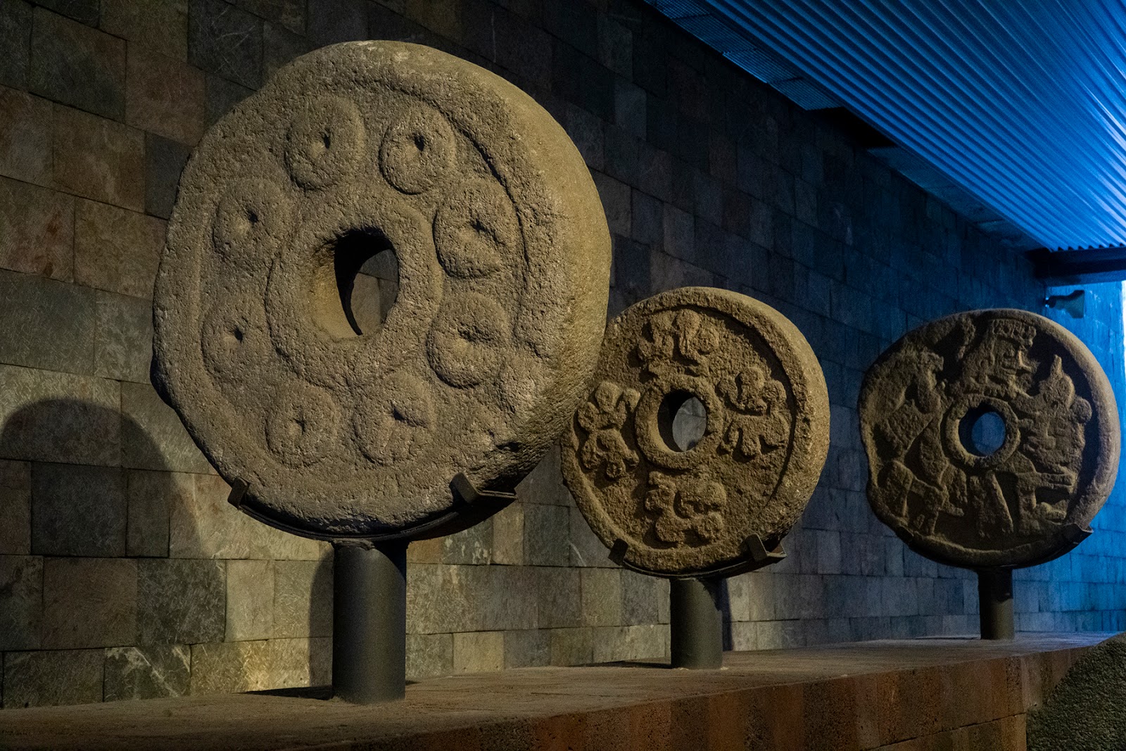
Ball Court Hoop, Anthropology Museum, Mexico City (Author's collection. copyright 2019)


Due to their out-lying locations, it is surmised that these two sites were actually trading posts due to their proximity to Chacoan/Mogollon settlements.  Commerce activity in this region was very dynamic during this entire period and shouldn’t be thought of as locked containers passing customs checks with end user certificates for verification or even clipboards with inventory lists received via Email.  It was more like the old town five and dime store owner who was aware of all facets of inventory and supply/demand in his head because he was familiar with every nuance of change that his town and customers experienced.  

                          
Ball court marker, Teotihuacan (Author's collection. copyright 2019)
Trade continued like this for a long time but in about 1,000 AD things began to change; that is when social complexity changed in the Sinaloa region of today’s Mexico: the southern end of the Chihuahua Corridor.  The Chalchihuites were the northern most representatives of Mesoamerica culture and between 950 and 1150 AD their seat of power was the city of Zape in northern Durango.

Ball court hoops from Teotihuacan, Anthropology Museum, Mexico City (Author's collection. copyright 2019)


Monday, October 14, 2019

Loose Ends, Part One

    Mexico City is known for many things - especially their upcoming annual celebration of Día de Muertos, but the city’s involvement in the closing chapter of the Bolshevik Revolution is little known.  It was on a sticky afternoon in August of 1940 in the now stylish borough of Coyoacán that the Bolshevik Revolution wrote its final note as the people’s rebellion.  

 Lev Davidovich Bronstein, AKA Leon Trotsky (Author's collection)

     Vladimir Lenin and Leon Trotsky had built the Russian Revolution to empower the Russian people to rise up against their oppressive Monarch, Tsar Nicholas II but their overall idea was to create a system for world-wide revolution - throwing off the "oppressive" cloak of capitalism and empowering the people.  Though the Bolsheviks did a good job of harnessing some of the rampant public discontent extant in Russia at the time, there were many groups actively engaged in subversion in and around St. Petersburg in 1917 and Leon Trotsky was a leader within one of those socialist/communist groups, the  Menshevik’s.  Because of mounting turmoil, Tsar Nicholas abdicated in March of 1917 and an interim government was set up to try and repair the nation’s economy and social unrest all while fighting World War I.  The spark of public agitation was fanned to flames by groups like the Mensheviks and the Bolsheviks but it wasn’t until the Germans freed Vladimir Ilyich Lenin from one of their prisons and put him on a train back to St. Petersburg that things began to really heat up.  Just before the October revolution, Trotsky joined the Bolshevik party and was an immediate "insider" who went on to be one of the original seven on the first Politburo which led and directed the Bolshevik revolution. From the October revolution, widespread pandemonium ensued and it was obvious that the Bolsheviks didn’t stand a chance of leading Russia into communism.  The Bolsheviks were ardent writers and loquacious orators but their ability to create useful policy AND put it into place was another thing all together and yet, somehow, they survived.

Secretary office in the house of Trotsky, Mexico City. (Author's Collection, copyright 2019)


    To make a long story short, Russia made a separate peace with Germany, a civil war ensued and countless Russian innocents were murdered while inept policies were implemented and overturned repeatedly and the Bolsheviks blamed everyone but themselves for their failures.  As these failures became apparent, the Soviets (the new name for the Bolsheviks) began to rule the people more harshly.  Questions were met with beatings and dissent with bullets.  During all of this, Trotsky continued to rise through the party ranks.

Trotsky's desk, where he died. (Author's collection. copyright  2019)

Monday, September 30, 2019

Caught up in the Rush

    The temperature of the light is quite different in America than in Egypt but that is hard to see from my basement.  I've been stuck here since my return, processing images and accounting for finances.  That is the reason I have no entry for this week and I am making excuses instead of interesting analogies.
    Forgive me, my trespasses.

Swirling Clarity (Author's Collection copyright 2018)

Monday, September 16, 2019

Genetic Encoding, Part Two of Two

  In fact, in Egyptian history it is rare to find changes that were instigated by the masses.  External factors were almost always coming to bear on the people of this great country and those factors were typically “top down” changes.  

Cario in the morning
(Author's Collection, copyright 2019)

Adjusting to these changes was for them to deal with as leaders are rarely concerned with (and quite often unaware) of the daily difficulties that are enacted when they flippantly decide to do something.  Self-righteous Pharaohs, impetuous rulers, colonial oversight and exploitation by empires are but some of the ancient examples of difficulties that the average Egyptian had to contend with but the recent past isn’t any better.


Fast Food in Cairo's Market
(Author's Collection, copyright 2019)


    Recent political turmoil has built upon decades of questionable national level decisions which have created a poor educational system and created mass poverty (average annual income is 6,700USD).  A by-product of this situation is growing sectarian violence and increasing economic instability- the uneducated can’t be expected to make informed decisions or develop insightful philosophical points of view.  


Streets of Imbabah
(Author's Collection, copyright 2019)


In response, the Egyptian Government recently de-valued their currency (Egyptian Pound) and made severe cuts to public subsidisation/aide programs.  This was all in an effort to qualify for a large loan from the International Monetary Fund (IMF) which the Egyptian Government hopes will stimulate the economy before the more impoverished segment of society is crushed.  Does Egypt (or the world) really need another lane in the Suez Canal?


Egyptian Museum Entrance
(Author's Collection, copyright 2019)

Through all of this, as they have for millennia, Egyptians continue to adjust and compensate for the external factors pressing on their efforts for a better tomorrow.  Without considering all these historical factors, Egyptians live their lives and try to adapt to the radically changing socio-political and economic landscape; doing the best they can before the next change is forced upon them without their consent.  As though adaptation and adjustment have been imprinted in their genetic code.


Monday, September 9, 2019

Genetic Encoding. Part one of two

    250,000 BC is the earliest date of human activity in the area we now call Egypt and by 3,100 BC, legend tells us a Pharaoh by the name of Narmer had united the region between the Mediterranean Sea and the first cataract (present day Aswan).  For the inhabitants of this region, they have changed and adapted so many times that they are unaware of their innate ability to compensate for the inconsistencies of others.  
    
Egyptian Hieroglyphs, Egyptian Museum (Author's collection copyright 2019)

    During our 247,000 year interval between the above dates Africa became victim of climate change and the rich savannahs became arid, forcing the nomads living there to migrate closer to the Nile River.  Rains further south ensured that the Nile flooded annually - like clockwork - and when those floodwaters tapered off the soil of the surrounding countryside was enriched by silt and soils from all over eastern Africa.  This presented the opportunity to farm and Egyptians don’t hesitate to capitalise on something good.  Sadly, one must take the good with the bad in life and social order came along with farming and Pharaoh placed himself at the top- as all leaders do - and the farmers at the bottom.  Pharaoh himself is credited with establishing social order but the claim is buttressed by archaeological evidence from 3000 BC (circa).

    
Pyramids of Giza(Author's Collection, copyright 2019)

This simple restructuring forced many changes on the population of ancient Egypt but nature did too and the flood period provided a natural respite for farmers which Pharaoh most likely capitalised on by using them as unskilled labour supporting his engineers and architects in building his elaborate infrastructure.  What a summer job, building those magnificent pyramids and monuments, even if you are just hauling baskets full of rubble.  The chaos caused through the ensuing years by multiple changes to the physical location of the Egyptian capital, not to mention adjustments and refinements to the state religions must have had a disorienting effect on the populace but they kept working, trying to make a better tomorrow for them and their families.

Monday, September 2, 2019

A Code to Live By

    Our western traditions in the last 50 years have left something to be desired with regard to how we comport ourselves.  In the last twenty years it seems that people are more concerned with how they look than how they really are.  As proof, steal a glance at someone’s credit card bill next time you have a chance: 85% chance says it is disproportionately high indicating they are living outside their means.   I’ve even heard words like tradition and honour used as punchlines to jokes recently, though no one was ever laughing once I was done with the comedian.

 (Author's Collection. Copyright 2018)
    As a child, cowboy and samurai movies were our favourites because everyone knew what to expect, which means they had a code requiring they act in a certain manner.  While that was just Hollywood, these actions were based on a real code of honour that existed for a long time and allowed the world to function in a manner that imparted balance.  Historically, the warrior class has transcended cultures: the Knights of Europe could identify with the Persian cataphracts and both would have understood the code of Bushido embodied by the Japanese Samurai (attendant), and later, Bushi (warrior) class.
    From 1639 to 1854 AD, Japan employed the policy of sakoku (national isolation).  This was their response to dampen the myriad external pressures exerted on Japan while the Shogun consolidated his hold over the island.  This produced many peculiarities which make their culture so unique, of which, Bushido (the way of the warrior) is but one part.  An administrative restructuring under the Tokugawa Regime saw the Samurai removed from their rural landholdings and placed closer to their lord’s precincts.  Now being paid in rice instead of having to farm for their income, the Bushi found themselves very idle in their daily requirements.  This created the opportunity for a professional class of warrior never seen before: culminating in a daily regimen dedicated to the cultivation of all things martial.  The underlying influence exerted by Zen Buddhism created a thirst for perfection in all aspects of life for the warrior class of Japan and this can be seen today in the minute details associated with many of their martial arts.  Whether drawing a sword or flipping an opponent, the determination to emulate the Buddha in his quest for perfection permeated their daily lives and bled over into their efforts to pour tea or serenely sit while contemplating the world.
     This entire system was only attained through a concerted effort to codify and institutionalise the traditional practice of selected philosophies which, over the centuries, became cultural norm.  Ultimately, it was this cultural norm that empowered the feudal way of life and acquired a level of national discipline that would enable japan to adapt to the modern world so quickly.  
    It is the presence of a code of honour that is so lacking in modern society and which will ultimately be the basis for the ruination of humanity.  One must stand for something or agree to fall for everything.

 (Author's Collection. Copyright 2017)


Monday, August 26, 2019

If it Ain’t Broke…


    I am neither an architect nor an Engineer by trade.  I am a natural tinkerer and have spent most of my life breaking my toys, so I have an appreciation for how things are made and what it takes to make them.  As such, I spend a lot of time noticing differences in construction: things like the pathetic stitching on the snaps of Hasbro’s G.I. Joe camouflage fatigues the last year they were made.  Incidentally, I still have a set of those cammies from their first year of production.  Bombproof!
    This is all a way of saying that newer isn’t necessarily better.  Last week I was watching a re-run of a World War Two documentary in which Germany invaded France by running around the Maginot line.  While discussing river crossings and their importance to military operations, historic film reels were played showing a German tank crossing a makeshift bridge; one hastily constructed from little more than timbers laid across numerous small boats.  This bridge struck me as familiar and I began to sift through my library for references to this construction as it seemed out of place in this German war footage.

Screenshot of bridge by author

   I worked backwards in time and was consulting J. Caesar’s The Gallic War without finding my bridge, so I looked further back in time.  Finally, I found it.  The description went something like this:  
    
Many boats (654) were placed side-by-side and facing into the current while cables were used to secure them to the shore and the individual bows were anchored up and down stream to keep the boats in line relative to each other and adding more stability.  Boards were then placed between the boats and over the cables to connect them while brushwood and soil were placed over the boards to create a walkway and a more even surface after which a handrail was placed on either side to keep soldiers and beasts of burden from falling in. 


Author's image of a bridge in Afghanistan taken from The Histories

    This resource that listed my bridge was actually Herodotus when his Histories were describing how the Persian Empire invaded Greece.  Xerxes used this bridge type to cross the Hellespont in 482BC (circa).  This narrows is approximately 1240 metres (1350 yards) of the most difficult waters in the world.  This successful iteration was actually the second effort.  The first had ended badly for all: the engineering supervisors were beheaded and the waters of the Hellespont were flogged with 300 lashes while being subjected to verbal abuse for being disobedient.  


Author's image of a sketch from The Histories  


So, in 2019 I saw a film from 1939 which spoke about how technologically advanced the German Army was and how incorporating this technology gave the Germans a battlefield advantage.  Yet in this film, our twentieth century technological genius’ used a bridging technique from 2,421 years earlier.  Perhaps part of their genius was their ability to recognise when something works well.

Monday, August 19, 2019

Greek Fire


    Since the dawn of time man has been competitive.  Perhaps that is what has set him apart from the rest of the animal kingdom: Faster, farther, better - regardless of the endeavour.  This is especially true in warfare.  More efficient means of vanquishing the opponent has always found an audience: and so it was with Greek Fire.

    In the early days of the Greek city states and of the Roman Empire, the use of incendiaries in combat was rampant and the unpredictable nature of Greek Fire made it as hazardous to the employer as it was to the intended victim.  Yet, the ability to throw fire from one point to another in a focused and directed manner was very desirable, so pyro-masters kept refining the process through trial and error.  Finally, in about 668AD, a Greek refugee from Syria arrived at Constantinople with a proven recipe.  By 672, Kallinikos, as our Greek was called, had perfected his delivery technique and was using it to defend the Eastern Roman Empire against invaders.  Legend has it that this version could set water on fire and actually burn underwater.  

Image of a 12th century manuscript (Author's collection)
    All mythology and nonsense, right?  Except that napalm and white phosphorous fit these descriptions and were used to great effect during the wars of the twentieth century.  Throughout time there were other munitions that created races to develop and acquire regardless of the cost in dollars or humanity.  The atomic bomb is an excellent example of today’s Greek Fire as the centre of the mushroom cloud over Hiroshima, Japan reached five thousand degrees centigrade.  Add to that the fact that the second bomb (made of plutonium, not uranium) was so unstable that it had to be tested in the New Mexico desert prior to being dropped on Nagasaki and due to the arms race (both before and after) created by its introduction we see many parallels with Greek Fire. 

    Even today, the search for the proper recipe continues.  In early August 2019, there was an explosion west of Archangel, Russia and, subsequently, the town of Nenoksa was evacuated and all this was conducted under a veil of mis-information and retracted statements by the Russian Government.  What ever their cover-story may be, the most likely happenstance is this: The Russian military was testing a Skyfall missile (a nuclear missile powered by a nuclear reactor) that went awry.  The best bet is that its portable nuclear power station melted down in a smaller version of the Chernobyl, Ukraine tragedy.  Most certainly, the power station was one of a new offering by the Russian firm Rosatom.  Rosatom stated last year that they envisioned their new portable reactors being used in a fleet of nuclear-powered ice-breaking ships in support of Russia’s efforts to open (then dominate) the Northern Sea Route: thus connecting the Atlantic and Pacific Oceans via the Artic.

    Keep in mind that through all of this, Russia has no overt enemies and the only international enmity directed towards them is because of their meddling in external, sovereign affairs.
Close-up of the above manuscript (Author's collection)


Is this the fallout from today’s Greek Fire?