Showing posts with label Cultural. Show all posts

Monday, March 16, 2020

A Land of Myth, Mystery or Men?

 So if this Golden Fleece thing was just a smash and grab job, why is Georgia so important?  

    It would seem that Georgia has been a crucible for mankind since before we were mankind.  As related in an earlier edition, multiple Pre-Homo Sapien specimens have been found in the region of Dmanisi.  Under present anthropological understanding, the importance of this find would have been meaningless - or worse, mis-interpreted - were they not found in such close proximity to each other, as in Dmanisi.  As I understand it from reading in the Georgian National Museum, this has never been found before.  Why were our earliest humanoid species discovered together outside Africa in Georgia?  A distance of at least 1,600 kilometres (1000 miles).  Could they have been at the meeting with God (entry 24 February 2020)?


Skull, Homo-erectus(Author's collection)


    As noted in the last several entries, evidence of contact between Hellenic Greece and western Georgia was effected in approximately1200BC through Jason and his Argonauts but their knowledge of the Golden Fleece in Greece begs the question: who told them about it?

    In Greek Mythology we encounter Prometheus.  A demi-god of the heroic nature but one that ran afoul of his full-blooded cousins by stealing the secret of fire and giving it to mankind.  For this transgression, he was chained to a mountain top where an eagle pecked his liver out by day and it re-constituted itself by night.  That mountaintop was non other than Mount Kazbegi located in Georgia on the border with Russia along the Georgian Military Highway.  Georgian mythology has a similar character who suffered the same fate named Amirani.  Did Jason return with that bit of information too?


Mount Kazbegi centre image (Author's collection copyright 2020)


    The concentration of unique languages is prolific in the Caucasus as well.  It seems that every mountaintop speaks a different language (not dialect) and most are too old to have an alphabet.  The Georgian alphabet itself is among the oldest in the world.  Interestingly, mythology comes to the rescue here as well.  Local legend has it that while distributing languages to the world’s people, God placed all the languages in large panniers and mounted them on a donkey for easier transport.  While walking over the Greater Caucasus Mountains, the high, jagged peaks tore the bottom of the panniers and many languages fell across that small area before the holes were patched.


Georgian village in Svaneti Region of Georgia
(Author's collection copyright 2020)


    Life in the Caucasus has never been easy and it takes a hearty breed to survive.  It stands to reason that anyone standing out in a crowd like that would be legendary in their exploits.  This holds true for Georgia.  Many larger-than-life characters have existed throughout time.  King Vakhtang Gorgasali was said to have been deer hunting one day in the fifth century AD.  He was in an unfamiliar region, a bog-ridden area next to the Mtkvari River when he wounded a stag with an arrow.  King Vakhtang chased the wounded deer into the bogs where it disappeared from site through the morning mist but he heard it fall into the marshy waters.  So sure was he that the animal was dead that he ran forward unprepared, only to see the stag emerge from the waters unharmed and run away unscathed.  Bewildered by this, he investigated the reason for it and is credited with discovering the curative waters which gave rise to the city of Tbilisi: the capital of today’s Georgia.


Hamams in Old Towne Tbilisi (Author's collection, copyright 2020)


    Later, after a war with the Ottoman Empire, Tsarist Russia was trying to “Tame” their recent acquisition called Georgia and many a hard man was drawn to the Caucasus to test his mettle and make his fame.  In fact, a large body of Russian literature is linked to the wars of oppression in the Caucasus and one of the greatest insurgencies ever fought took place there: driven by the unbending will of its best known leader, Imam Shamil, an Avar from today's Daghestan.  With drive in mind, history would soon recognise another Georgian: Ioseb Dzhugashvshvili.  We remember him as Josef Stalin and he killed millions of people trying to impose his will on the world under the guise of communism.  


     Perhaps, unbending will is the true mystery of the land God reserved for himself.  Each individual I met there, over decades of interaction, was a force to be reckoned with - men and women both.  So if the region's mystery is, indeed, the unbending will of men, Caucasians most likely created the circumstances from which myth emerged and with this en-ending supply of wilful people, the Caucasus has remained prominent in the development of mankind since the dawn of time.


Monday, March 9, 2020

So what really happened?

      Legend tells us that a generation before the Trojan War, in ancient Thessaly, King Pelias stole the throne from his half-brother King Aeson.  In doing this, Pelias made a dangerous enemy in Aeson’s son, Jason, but sent him off on a quest to the empire of Colchis (modern day Georgia).  If completed successfully, this quest had the ultimate pay-off - Jason would be crowned king of Pelias and if he failed, Jason would pay the ultimate price.  To this end, Jason surrounded himself with some of the greatest heroes of the day and it was these heroes and their exploits that grew into legend.  This is the story first related in the third millennium BC by Apollonius of Rhodes entitled, The Argonautica.
All legends are based in truth and this one is no different.  It would appear that wealth and nation building were paramount to would-be-kings even thousands of years ago.  All empires need a financial reserve as well as sustained revenue and it was well known that Colchis was rich in gold. What made them so rich was their particular methods of acquisition.  The Rioni River and its tributaries were populated with wooden vessels outfitted with sheep skins that would take advantage of the rivers’ currents to sift the gold particles as they flowed out of the Greater Caucasus Mountains.  It is not hard to believe that over the millennia, such a simple but revolutionary technique would become the myth of the Golden Fleece.

Colchian earrings - circa 1st millennia BC. (Author's collection, Copyright 2020)

If true, it would seem that the real reason for this exploit was the acquisition of technology - not a simple smash-and-grab robbery.  Think of it like the old adage, “give a man a fish and feed him for a day.  Teach him to fish and you’ve fed him for life.”  Is that the real reason Jason surrounded himself with demi-gods?  How else could one expect to acquire such sensitive information?  

Jason knew that he had to have every skillset possible in order to have any chance of success.  

       Historians and storytellers differ in their passenger list aboard the Argo but generally agree that 50 crewmen were necessary and among the crew there are a few names that always appear: Heracles, Castor, Pollux, Peleus and Telamon.  It was these men, with their varied specialties and capabilities, who had been brothers in arms for such a long time that made Jason's success nearly a forgone conclusion.

Necklace from Vani, Georgia - circa 1st Millennia BC. (Author's collection.  Copyright 2020)


So we see that financial stability and corporate espionage were most likely the basis for the exploits we call the Quest for the Golden Fleece and in an effort to ensure success, Jason surrounded himself with men capable of a variety of skills - skills like; cunning, strength, intelligence and endurance.  Skills that may or may not be required for success but whose lack, when needed, would ensure failure. 
        Yet, in the end we see that for all his planning, preparation and coordination, it was an unforeseen capability that won the day for Jason: magic.  The magic of love when Medea fell for Jason and agreed to help him steal the Golden Fleece from her father, King Aeetes of Colchis.

Bracelet from tomb in Vani, Georgia - circa 1st Millennia BC.
(Author's collection. Copyright 2020)


Monday, March 2, 2020

Origins of the Golden Fleece Myth

    In European culture seeking wisdom - especially hidden knowledge - finds its reflection in the symbols associated with gold: the Golden Fleece, the Philosopher’s Stone and the Holy Grail.  For all the qualities it embraces - this eternal and most noble of metals - gold was recognised as the metal of the sun.  It has become the foremost physical medium for the expression of men’s spiritual endeavours and the scientific knowledge about working gold is seen as one of the revelations of wisdom itself.

Detail on a 18th century BC cup from Trialeti depicting a religious ceremony.
(Author's Collection. Copyright 2020)

  The two phenomena: gold and knowledge, especially the knowledge of gold amongst the Colchians, were the genesis for rationalising the myth of the Golden Fleece.  It was this Golden Fleece that was the main goal of the first long-distance maritime adventure in mankind’s recorded history.  The Greek philosopher and mythographer Euhemerus went so far as to interpret the Golden Fleece as a technique of writing in gold on parchment or a book written on skins which describes the method of obtaining gold by means of chemistry.

Fourth century BC example of Colchian goldsmith techniques.
(Author's collection.  Copyright 2020)


  Why is the myth of the Golden Fleece - which emerged from the culture of classical antiquity and pursued its life in the alchemy of Medieval Europe - connected to Colchis?  The answer to this question may be found in Greek written sources that mention Colchis as “rich in gold”, similar to the cities of Mycenae, Sardis and Babylon which were all famed for their wealth.  Perhaps more significantly, the answer lies in the knowledge of obtaining, working and using gold for high spiritual goals - the wisdom that was continuously refined, preserved and passed down throughout the centuries in the territory of Colchis and the entire country of Georgia. Today we witness the demonstration of this wisdom in the golden artefacts found all around the country we call Georgia and we continue to re-discover these techniques and knowledge through our study of these pieces of history.

Colchian fourth century(approx) plaque depicting bull, boar and lion.
(Author's collection. Copyright 2020)


Monday, February 24, 2020

Why Colchis?


"The wealth of the regions about Colchis, which is derived from the mines of gold, silver, iron and copper, suggests a reasonable motive for the expedition of Jason."

Strabo, Geographica, 1.2.39


Excavation at Vani, Georgia - Colchian city.  (Author's Collection. Copyright 2020)

    In today’s “age of reason”, we use science to explain our world.  In the previous world it was religion that explained how things worked and before that, it was myth that gave reason to our world.  

Strangely, even today, the Caucasus is a world of myth.

    Myths and legends carry a powerful message through time - how the tellers of these tales view themselves.  Every tribe under the sun has these stories - each rooted in a time too distant to remember and each of them fascinating.  Yet all of these legends have one thing in common - they stand the test of time.  We, as people, are inextricably bound to the past: it makes us what we are today and shapes what we will become tomorrow.  One could even say that without the past there would be no future.


Waterfront in Batumi, Georgia - eastern Black Sea (Author's Collection. Copyright 2020)

    Strabo describes the wealth of an ancient civilisation as the plausible impetus for one of history’s most enduring myths but perhaps the wealth described by Strabo above can be explained by an even older Georgian myth.

In the beginning, God created the Earth and all its people.  He then asked all the people to attend a gathering so that he may parcel out all the lands of the Earth to them for habitation.  On the appointed day, all the peoples of Earth gathered and received, from God, what we call today their ancestral homelands.  Conspicuously, one group of people was not present, but God went ahead and gave the lands out as gifts to those that were.  Once all the lands were dispersed and the people departed from the gathering, the one missing group arrived.  God said unto them, “My children, I’m sorry but you are late and no land is left to be given unto you as a home.  Where have you been?”  The group replied to God that they had been feasting and toasting God’s good name and his benevolence and, according to their traditions, could not stop the feast in order to attend his meeting.  They apologised profusely but re-iterated that they were late because their particular form of worship had deterred them from arriving on time.  So the Lord spoke to this group of people and said, “You are a genuine and pious people who deserve a good homeland, as such, I will give unto you the place on Earth I had reserved for myself: Georgia.


10th century AD (approx) ruins overlooking Rioni River 
from Bagrati Cathedral in Kutaisi, Georgia
(Author's collection. Copyright 2020)

    God’s reservation of Georgia as his own refuge could be an acceptable reason for us to believe in the incredible mineral wealth of the region and through time, this could have manifested itself in the great wealth of the empire of Colchis.  This empire on the eastern end of the Black Sea in today’s Georgia was the target of Jason and his boatload of adventuring heroes.

Colchian anthropomorphic figures in main sqaure fountain. Kutasisi, Georgia
(Author's collection. Copyright 2020)


Monday, January 27, 2020

Time and Patience: the Most Powerful Warriors. Part Six

    Our quest for calendrical stations continues on the western end of Chaco Canyon.  Peñasco Blanco was rumoured to have a calendrical station marked by standing stones (according to Cosmo Mindellef in 1891) but the area can’t be found today.  Even further west, approximately five kilometres, is another great house: Casa del Rio.  This relatively small house (21-27 rooms), strangely, has produced the largest refuse pile of any other Chaco Canyon house.  It is along the Great West Road and has signs across the site of increased pedestrian traffic which may indicate avenues of ritual procession.  Additionally, the amount of refuse being dumped here decreased in/around 1100AD - just when a resurgence of building in Chaco Canyon proper began.  This all may suggest that Casa del Rio was a very important early festival site.  Visually, from Casa del Rio the Winter Solstice sun would have risen over a shrine on West Mesa named 29SJ 1088 - which sits on the highest feature on the southeastern horizon from Casa del Rio.  Additionally, use of selenite reflectors or fires would allow for instantaneous notification over the eight plus kilometres distance into downtown Chaco(Signal Towers, another topic for another entry).  
    The last category has to do with the larger application of Chaco Canyon itself as an observatory.  Recent data concerning this was uncovered by Anna Sofaer, Robert Weiner and William Stone and published in 2016 in The Science of Time 2016, entitled, Inter-Site Alignments of Prehistoric Shrines in Chaco Canyon to the Major Lunar Standstill.  

Satellite imagery showing location/inter-relationship of Chacoan shrines relative to the major Lunar standstill (taken from Inter-Site Alignments of Prehistoric Shrines in Chaco Canyon to the Major Lunar Standstill, 2016)
This paper outlines the discovery of numerous masonry shrines spanning the distance of five to 15 kilometres which are aligned to the major lunar standstill.  This hypothesis is re-enforced by Geographic Information System (GIS) analysis of the spatial distribution of these sites and includes precise geodetic coordinates determined by the National Oceanic and Atmospheric Administration’s Geodetic Survey.  This data clearly shows these shrines and their inter-relationships along azimuths to the rising and setting moon at its major standstill. 

Azimuths between Chacoan shrines in previous image ((taken from Inter-Site Alignments of Prehistoric Shrines in Chaco Canyon to the Major Lunar Standstill, 2016)


    Overall, the evidence for calendrical stations in Chaco Canyon is overwhelming.  It is for us to try to decipher what they mean and what their role was in Chacoan culture.  It would seem that Chacoans did their best to improve calendrical precision by increasing vigilance in broader patterns across the ground while improving the speed of reporting to the central authorities.  With this in mind, we should ascertain that calendrical reporting was of paramount importance in the canyon.  Whether this was simply for projecting best corn and bean planting dates or used as a force multiplier in their quest for regional economic dominance may never be known.

Monday, January 20, 2020

Time and Patience: The Most Powerful Warriors. Part Five


    The calendrical station is our last subject concerning archaeoastronomy in Chaco Canyon.  This most recent subject is one of great controversy due to the willingness (seemingly) of some investigators to use irrelevant information in a relevant manner in order to aggrandise the Chacoan culture (alla Keynesian economics).  There is no need for that as Chacoan astronomy and its resultant culture are mind-boggling.  We will stick to facts alone in this article.
    Chacoans watched the sky, day and night.  Ethnographic proof is evident in every Pueblo tribe extant today and some are more ardent watchers than others but every tribe has astronomers.  This overwhelming commonality speaks volumes about the importance of the sky to Ancestral Puebloans.  

Super nova pictograph below Penasco Blanco.  Thought to be from an event in 1054 when an imploding star was visible during the day.
(Author's collection. copyright 2019)

Calendrical stations, simply put, are specific locations from which to track celestial activity across the sky.  Besides being a nice, relaxing pastime, this activity is the key to successfully charting solar activity as it relates to the time of year and - in a larger sense - when to conduct certain activities, like the planting of crops.  Properly conducted, this activity also allowed the Chacoan hierarchy to prepare the masses for upcoming festivals.  This would allow pilgrims travelling from satellite regions to be on time as well as markets to be prepared for the pending events: markets which strengthened the economy of the Chacoan World and re-inforced the validity of its ruling class.
    In Chaco Canyon there are several examples of calendrical stations and they are all linked to the fluorescence period.  In large part, these sites are associated with winter solstice prediction and are located near the Wijiji and Kin Kletso Great Houses as well Headquaters Site A (a backfilled site near Una Vida Great House).
   The original construction of Kin Kletso was completed by 1130AD (approx) and contains both anticipatory and confirmatory markers of the Winter Solstice.  Aligning the southern wall of Kin Kletso with the base of the cliff to the southeast gives a 16 - 17 day anticipation of the solar event and sighting the northern wall against the same cliff base indicates the day of the solstice itself.  Additionally, a large boulder near the north wall may have been the original calendrical station prior to construction.
    
Kin Kletso looking SW from canyon rim.  Previous calendrical station is the large rock (on canyon floor) in upper right picture in line with structure's north wall (Author's collection.  Copyright 2019)
    In the eastern end of Chaco Canyon is another great house: Wijiji.  This location was apparently built in one effort in 1110AD (approx) and was never occupied, lending credence to the supposition that it was created specifically as a calendrical station and fuelling speculation that this was an effort to revitalise a faltering religio-economy.  This great house exhibits signs of both anticipatory and confirmatory  stations in its architecture as well as in the surrounding terrain.  When standing at the northwest corner of the structure looking southeast, there is an apparent notch on the distant horizon.  16-17 days prior to the Winter Solstice sees the sun rising from just North (left) of this notch and the sun rises just to the South (right) of this notch on the solstice itself.  It is the preponderance of these visual astronomy references in Late-Bonito Phases great houses that is most interesting.  This site at Wijiji is impressive due to the number of calendrical stations in its vicinity.  To the East of Wijiji, there are boulders at three different locations that, coupled with a horizon foresight, act as calendrical stations for Winter Solstice, both equinoxes and Summer Solstice.  There is evidence that these sites were used subsequently by Pueblo tribes as well.


Monday, January 13, 2020

Time and Patience: the Most Powerful Warriors. Part Four

Another manifestation of Archaeoastronomy extant in Chaco Canyon is Cardinal       alignments.  North-South and East-West building orientations predominated during the flouresence period in the canyon (1000-1175 AD circa) and were so important by that stage that, in the case of Pueblo Bonito, an existing great house was expanded upon and re-oriented from the original S/SE floorpan to North-South alignment.

(Imagery courtesy of Google Earth)


    As opposed to the ancestral veneration as the basis for the S/SE orientation, I have found no clear ethnographic reasons for the cardinal alignment.  In fact, our concept of the cardinal directions would not have existed for the Chacoans; their understanding of the world was not like ours.  Perhaps the emerging reliance upon North-South alignments during the fluorescence stemmed from Chacoan understanding of the rotation of the cosmos through direct observation.  Long term observation of their revolving skies may have brought them to the conclusion that the cosmos rotates from a single point on either end of their world (North-South).  Their daily observation of the sun’s patterns - either through direct monitoring, horizon calendars or employment of a gnomonic device (see part two) - would have given them a good understanding of what we call East-West and, together, these concepts could have been employed to revitalise a flagging theocratic civilisation based upon this new cosmic concept.  
    These rumination aside, we are left with only the facts. The reasons for these orientations are not clear, there appears to be no utilitarian reason for the cardinal alignment (much less its sudden importance) and there are no topographical restrictions that would require construction to adhere so closely to these alignments.  The collection of solar heating may have been a factor in general south facing construction but there is nothing extant to insinuate such strict adherence to a cardinal azimuth.  Recent archaeological activity in Chaco Canyon suggests that even at the height of its fluorescence, Chaco Canyon had a rather small population that population surged at intermittent periods.  This suggests a religious employment of the site and would explain why the area was so well organised and such care was taken in its large-scale construction.  In this scenario (religious centre) the attention to detail would make sense if these great houses were built as physical manifestations of Ancestral Puebloan’s cosmic concept.  If this idea were true, even the act of building the great houses would have become an act of faith or contrition.  An idea like that may be reason enough for individuals without knowledge of the wheel and no beasts of burden construct an intricate road system over which to transport tens of thousands of trees from distances of up to 80km for use in construction of these houses.
    The question is what happened to cause a change in construction management? During this fluorescence period - when a surge in great house construction took place - almost every building exhibits signs of cardinal point orientation and there are several cases of inter-site alignment along the cardinal points as well, which indicates an even greater level of civil engineering on behalf of the Chacoans.  The construction of several buildings within Chaco between 1040 and 1160 AD (finish dates) demonstrate a clear premeditation on behalf of the Chacoan leadership to inter-relate their construction developments with regards to their cosmic concept.  Pueblo Alto, New Alto, Tsin Kletsin and Casa Rinconada are all flourecence era construction that are not only built with respect to the N-S alignment but are also aligned to each other despite their positions being separated by almost five kilometres.   Pueblo Alto, finished in ~1040AD, with an internal alignment of 178.9º is directly North of Tsin Kletsin.  Tsin Kletsin, finished in ~1115AD and due South of Pueblo Alto - constructed with an internal alignment of 178.7º.  Interestingly, these two great houses are outside of the canyon proper, on the mesas North and South of the canyon and in sight of each other; leading to conspiracy theories concerning warning stations and internal strife.  New Alto is a smaller great house within sight of, and directly to the West of Pueblo Alto.  This New Alto great house was constructed in approximately 1130AD and is directly North (and also within sight of) Casa Rinconada.  Casa Rinconada is located in Chaco Canyon (away from other great houses) and was constructed in ~1060AD and has an internal alignment of 180.1º.


    Through all of this the enigma remains (or deepens) because as cardinal alignment began to supersede S/SE orientation as the predominant expression of archaeoastronomy in Chaco Canyon, we see that same S/SE orientation become predominant in the Totah Region of the Chacoan world.  This region was at the northern end of the Great North Road and the destination for many during the initial abandonment of Chaco Canyon.  This simultaneous shift seems to indicate a rift in cosmic concepts.  Perhaps those that believed in the old ways moved North and built Aztec and Salmon Great houses along with their associated outliers while the “new” philosophy of cardinal alignment took over in the Chaco core.  

Monday, December 23, 2019

Holiday Spirit - Part One

    As we celebrate this period of good will towards man, let us all take a moment to reflect on the similarity of the different holidays and realise we aren't as different as the evening news tries to tell us we are.  Each holiday is based in the hope for a better future - just the sentiment of the Winter Solstice.


Monday, December 9, 2019

Time and Patience: the Most Powerful Warriors. Part Three


    The nexus of astronomy and architecture is called archaeoastronomy and in Chaco Canyon, NM it is manifested in three predominant ways.  One of these is in front-facing South/Southeast (S/SE) orientated structures - we will discuss the other ways in future instalments of this topic.


Pueblo Pintado a S/SE orientated structure (~160 degrees)
(Author's collection. Copyright 2019)
    Buildings with S/SE orientation are well documented back to Basketmaker III pit houses (400-700AD) - well before the earliest great houses - and continued to be built through the middle of the Pueblo I Period (700-850AD).  Archaeological surveys find that the orientation azimuths range from 151 to 161degrees and this S/SE orientation was consistently applied to Chacoan architecture for 700 years (450-1140AD).  The fact that this orientation doesn’t deviate with latitudinal change suggests that it wasn’t based on direct regional celestial observation.  Additionally, the area where this S/SE orientation dominates is too large for a common-to-all terrain feature which could insinuate this azimuth on the Chacoan psyche. 
    With this in mind, I should surmise this orientation was culturally important to  Chacoans for reasons that are not readily clear and the consistent application of this azimuth over centuries also indicates the employment of some physical means.  
    There exists an ethno-archaeological basis for this cultural importance amongst the telling of Hopi migration stories about the Snake Clan which migrated from the Navajo Mountain region to the Black Mesa region of today’s Arizona - a heading of approximately 165 degrees.  A version of this migration story seems to be recounted by Cosmos Mindeleff in 1891.  
    ”…A brilliant star arose in the southeast, which would shine for a while and then disappear.  The old men said, ‘Beneath that star there must be people’, so they determined to travel towards it.  They cut a staff and set it in the ground and watched until the star reached its top, then they started and traveled as long as the star shone; when it disappeared they halted…sometimes many years elapsed before it appeared again.  When this occurred, our people built houses during their halt; they built both round and square houses…They waited until the star came to the top of the staff again, then they moved on.”


Mesoamerican religious staff from Teotihuacan, Mexico (circa 70AD)
(Author's collection. Copyright 2019)
The veracity of this statement is borne through the statement concerning housing - “they built both round and square houses”.  Archaeological proof exists all over the southwest today of pit houses like this from the Basketmaker periods.  Today we have no reason to believe that this doesn’t extend to the means of navigation employed as well.  They speak of a simple cut staff - NOT a cross-member or cross-staff as posited by JM Malville in his excellent 2011 paper.  To date there have been found multitudes of staffs and religious sceptres in Chacoan tombs throughout the region (as well as across Mesoamerica) and these staffs could easily be symbolic of the Gnomon navigational device described in Part two. 
    The ease of reproducing this bearing with a gnomon used as a carpenter’s square fulfils our hypothesis for a construction device used to reproduce this S/SE orientation.  Simultaneously, the employment of this simple tool, in this configuration, would negate the archaeological “smoking gun” that scholars are looking for to corroborate this theory.  The answer is hiding in plain sight, we just don’t know what we are looking at.
    All native American tribes extant demonstrate great reverence for their ancestors and there is no conflicting evidence in the case of Ancestral Puebloans.  If we couple that with the verifiable evidence from their migration myths, it isn’t unrealistic to extrapolate our hypothesis here that the south/southeast manifestation in archaeoastronomy in and around the Chacoan world was based on ancestral veneration.  In a further extrapolation, I posit the use of a simple astronomical tool - in use around the world for centuries prior - as a means of building those structures and the proof is in museums throughout the American Southwest labeled “Chacoan religious staff”.

Pueblo Bonito from the inside.  Originally S/SE orientated (~160degrees), later altered to North/South.
(Author's collection. Copyright 2019) 


Monday, December 2, 2019

Time and Patience, the Most Powerful Warriors. Part Two


    While writing notes on southeast orientation and Cardinal points, I realised that I must address some basic facts and ideas as a precursor to understanding the Chacoan astronomy/architecture nexus.  
    Time in our world is created by two activities; the spinning of the Earth and the Earth’s rotation around the Sun.  Due to the former we have sunrise and sunset (the time of day) and from the latter we enjoy the change of seasons (the time of year).  Through these two types of time, the sun weaves its way across our skies in specific, observable patterns and it was these patterns and conditions which were closely observed by the ancestral Puebloans and became intrinsic to their very existence.
    Through the migration vignette from part one we see that these ancients understood the concept of direction, even if they didn’t have a word for azimuth, declination or Altitude.  As proof today, we have their repeated use of specific directions in their architecture over centuries of building.  This could have been easily accomplished through the use of a gnomon.  The gnomon is a simple tool for determining direction/time through observation of the sun’s movement and was first developed in Babylon though examples exist in the ancient world from China to Peru.


    A gnomon is built by placing a straight stick vertically in level ground and marking the location of the stick’s shadow on the ground through the course of the day.  This will quickly reveal the Cardinal directions and the device is eerily similar to the star tracking “compass” stick described in our migration myth from part one.  With a little ingenuity, this device can be a mobile compass as well.  To employ it one has to first determine the desired direction of travel.  Runners are then sent towards that direction and in the opposite.  These runners merely determine a straight line path through the gnomon itself and begin movement in the desired direction - always traveling in three parties and always re-evaluating their direction using the previous two points and terrain references prior to advancing.  If the party becomes lost or unsure, they merely stop for a day, set up the gnomon, verify the directions and begin again.
North wall of Aztec West great house which is aligned with summer solstice sunrise
(Author's collection. copyright 2019)
    Through close observation over time, a gnomon can also determine the azimuth of the equinoxes and the solstices.  When this began to happen, our ancestral Puebloans were determining annual calendars through the sun’s predictable nature.  Every March and September 21, the Sun rises and sets on the East-West meridian and its declination (distance from the Equator to the Poles measured in degrees) is 0 out of a possible 90 degrees.  Additionally, the gnomon can track the sun’s behaviour through its Winter and Summer Solstice declinations which are a positive or negative 23.5 degrees depending on the time of year.   The gnomon can also determine the altitude of the sun, track the Moon's activity through the full moon cycle and is a carpenter's square.  When this level of expertise is reached, the gnomon is a formidable weapon for nation building.  Horizon calendars can be created and future plans can be made on a grand scale.  Those grand scale plans can be employed to serve specific purposes which can, ultimately, manipulate public opinion and ideals.  

    When utilised in this fashion, our gnomon ceases to be a simple stick in the ground and becomes a sceptre of national power.  In this simple devise lies the power to legitimise rulers by “commanding the heavens” and thus, compel subjects to build organised cosmic cities which create an infrastructure based on that cyclic nature.   Their hard work is rewarded by security, well-planned festivals and markets centred around these cosmic events which stabilise lifestyles, build a vibrant economy and, ultimately, come to define them as a culture.

Specific events tied to an horizon calendar providing anticipatory warning for festival preparation.   (Author's composition)


Monday, November 25, 2019

Time and Patience: the Most Powerful Warriors. Part One


    It has only been in the last 75 years that we have made time a commodity by wearing wrist watches.  Prior to that, those who could afford to wore pocket watches, cumbersome yet useful items once the owner modified his clothing to accommodate storage.  Before these inventions, time was measured in days or months and was seen as an enabler instead of our present day view of time as an external, unseen force showing us our limitations and failures.
    A thousand years ago in the Four Corners Region of the American southwest, time was experienced as a facilitator and an all-encompassing personal encounter.  From the very beginning, these ancient ones were in search of time itself - their mythology stories available to us today claim that in the time after entering this world and before they occupied Chaco Canyon, the Ancestral Puebloans were in a constant state of migration.  They moved in a south by southeastern direction using wooden staffs to measure their travel against a certain star that was only visible at certain times of the year.  Finally, when they reached Chaco Canyon they found a physical manifestation of time on earth.  


Penasco Blanco looking East into Chaco Canyon (Author's Collection, copyright 2019)

    Only recently with our computers and space-based telescopes have we determined what these stone-aged people knew with sticks and naked-eye star-gazing: Chaco Canyon is a calendrical station which is naturally aligned for calculating the 19 year lunar cycle.  To confirm (and ultimately  celebrate) this, Chacoans built redundant observatories for anticipating multiple astronomical dates which were important to them, their religion and their way of life.  Simultaneously, they developed their culture around physical infrastructure that re-enforced their connection to the cosmos.

PuebloBonito from Northern heights (Author's collection, copyright 2019)


    This time-consuming effort required patience in order to be effective.  Patience on a macro scale can be called commitment and it was this commitment to pursue a common vision that fuelled the Chacoan culture through the vicissitudes of the ages and the ravages of environmental difficulties.  During these centuries, they perfected their building techniques and built their concept of time into almost every great house extant as well as their extensive network of roads.  Along the way, Ancestral Puebloans developed a thriving system of “international commerce” by importing commodities that buttressed their religious ceremonies and, ultimately, supported their experience of time.
    In the end, the same patience required to build this manifestation of time undoubtedly had a great deal to do with the abandonment of their monuments because they understood the difficulties associated with building their world as opposed to existing in it.  It was their commitment to this concept of time which prompted them to walk away from their centuries of hard work before they were buried by it. 

 Kin Kletso Masonry (Author's collection, copyright 2019)


Monday, November 4, 2019

War by Other Means, Part two


    Beginning in 300 BC, the Hohokam tribes in today’s United States’ state of Arizona were heavily invested in the shell trade with Chacoan and Mogollon tribes.  To the extent that in the Papaguería area of today’s Tohono O’odham National Reservation, there is evidence of a large habitation site dedicated to the production and export of shells.  The period of 550-1150 AD saw the zenith of Mesoamerican goods finding their way into Hohokam culture via the Sonoran Corridor and it was in this time of increased Mesoamerica contact that Hohokam shell work achieved its highest artistic level.  As with trade, so too comes culture and Hohokam society seems to have absorbed a number of Mesoamerican traits: platform mounds and ball courts, to name a few.  In fact, by 600 AD there were even ball courts located at the remote Hohokam sites of Winona and Stony Canyon (outposts along the western birder of Chacoan territory).  
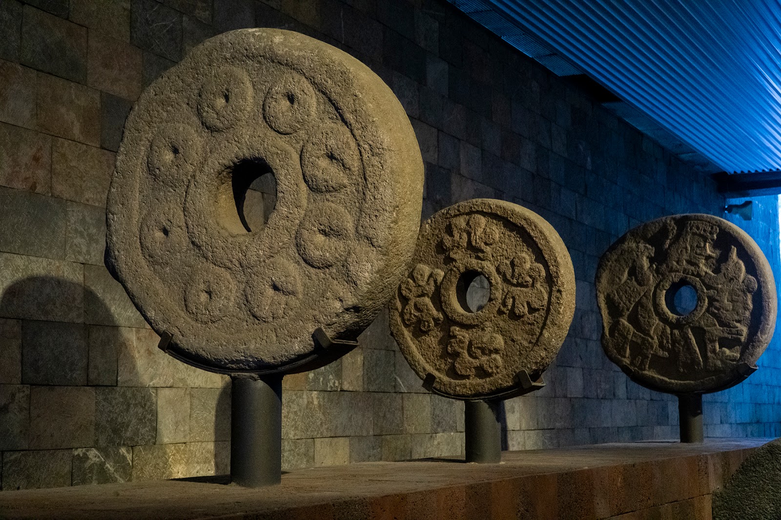
Ball Court Hoop, Anthropology Museum, Mexico City (Author's collection. copyright 2019)


Due to their out-lying locations, it is surmised that these two sites were actually trading posts due to their proximity to Chacoan/Mogollon settlements.  Commerce activity in this region was very dynamic during this entire period and shouldn’t be thought of as locked containers passing customs checks with end user certificates for verification or even clipboards with inventory lists received via Email.  It was more like the old town five and dime store owner who was aware of all facets of inventory and supply/demand in his head because he was familiar with every nuance of change that his town and customers experienced.  

                          
Ball court marker, Teotihuacan (Author's collection. copyright 2019)
Trade continued like this for a long time but in about 1,000 AD things began to change; that is when social complexity changed in the Sinaloa region of today’s Mexico: the southern end of the Chihuahua Corridor.  The Chalchihuites were the northern most representatives of Mesoamerica culture and between 950 and 1150 AD their seat of power was the city of Zape in northern Durango.

Ball court hoops from Teotihuacan, Anthropology Museum, Mexico City (Author's collection. copyright 2019)


Monday, October 28, 2019

War by Other Means, Part One


    Mesoamerica is a word that conjures images in the minds of westerners.  Images of colourfully decorated priests cutting the hearts out of victims atop perfectly built stone temples, the victims' blood pouring into cups via specially prepared troughs.  Images of a society girded for war while perfecting their concepts of astronomy and time and images of pyramids mysteriously abandoned for all time by their creators. 

Native dancer, Mexico City, Mexico (Author's collection,  copyright 2019)

Yet the truth is that the word is a mis-nomer.  It leads the listener to think of a single place, society or culture but Mesoamerica was anything but that.  For millennia, the region, which stretches from modern day Mexico to Costa Rica, was comprised of a conglomeration of city-states and a few empires, each of which rose and fell like all the other societies before and after them.  They traded far and wide with as many other tribes as possible but fighting amongst them was more often than not the norm.  Mayan, Olmec, Toltec, Chalchihuites, Mixtec, Zapotec and Teotihuacan to name a few, there were some who’s names aren’t even known.  One thing that is known is that commerce was a large part of each of these better known societies and commerce is  always dependent upon access to trade routes.  


Jackson Step, part of the Chacoan road system (Author's collection copyright 2019)

Two of those routes led from modern-day northwest Mexico into modern-day southwest United States.  The Hohokam Society of today’s American state of Arizona sat at the northern end of the Sonoran Corridor which ran along the Sonoran Coast and linked them to their suppliers, the Guasave culture.  The Ancestral-Puebloans (of Chaco Canyon) and the Mogollons sat at the northern end of the Chihuahua Corridor which wound along the eastern slopes of the Sierra Madre mountain range.  Each of these corridors allowed for the diffusion of Mesoamerica goods (and culture) to flow into the southwest.  Close examination of these circumstances reveals that ancient trade agreements were just as fragile as they are today and that trade wars were just as nasty then as they are now.